
USGS 3DEP LiDAR
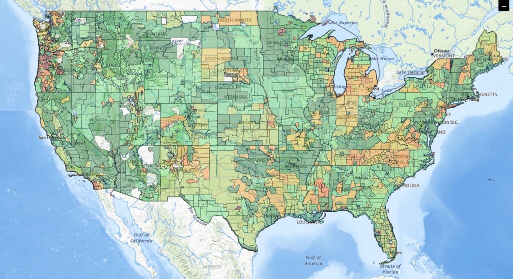 An approximately $1B USD investment to date, USGS 3DEP is one of the most ambitious and successful earth observation projects ever undertaken. Land Info has launched new cloud tools to query/download/stream USGS 3DEP LiDAR, making elevation data more accessible than ever.
The majority of the nation now has LiDAR (Light Detection and Ranging – an active sensor that’s the gold standard for elevation mapping) available, with all missing sections of the lower 48 states either in progress or under contract (there is full LiDAR coverage of Puerto Rico and USVI, partial coverage of Hawaii and Pacific Territories, Alaska is predominately radar-based.) LiDAR gives both a Digital Terrain Model (DTM) that represents bare-earth ground, and a Digital Surface Model (DSM) which models first-level surface, meaning it includes tops of trees, buildings and other above-ground objects. By subtracting the DTM from the DSM a normalized Digital Surface Model (nDSM, also known as a CHM or Canopy Height Model) can be created to show relative heights above ground, instead of absolute elevations.
Contact LAND INFO for a project recommendation.
For over thirty (30) years Land Info has been at the forefront of evolving elevation solutions:
- mid-1990s: scanned all 58,000+ USA topographic maps for USGS and used specialized SCO UNIX software (LT4X and Delta 3D) to create vector contours (DLG hypsography) and Digital Elevation Models (DEMs), not only of the USA but entire foreign countries
- 2000: purchased and custom processed the first USGS countrywide DEM, which at that time was known as National Elevation Dataset (NED)
- early-2000s: assembled Shuttle Radar Topography Mission (SRTM) near-global terrain dataset that was ultimately used extensively both in EDU research (distributed to over one hundred Universities) and on numerous commercial projects
- mid-2000s: one of the earliest users of commercial high-res optical stereo satellite imagery, the world’s first publicly-available solution for high-res remotely sensed elevation data for areas too remote, dangerous or restrictive to mobilize aircraft
- mid-2010s to present:
- one of the first companies to work extensively with Vricon (now Vantor Terrain) on commercial projects
- added off-the-shelf OTS optical SGM (semi-global matching, also known as Phodar) elevation models
- custom tasked crewed aerial 3D collections (LiDAR & optical)
- incorporated new radar satellite offerings including Airbus WorldDEM, WorldDEM Neo and ESA Copernicus DEM
- created the first USA nation-wide medium-resolution land-use/cover dataset that used both DSM and DTM inputs for classifications, ultimately adding nDSM for measured heights above ground
As use cases including 5G wireless rapidly evolved toward higher accuracy and resolution needs Land Info became a heavy user of 3DEP, USGS’s public-domain LiDAR. Our initial approach of downloading point cloud files and gridding to raster in desktop workstation environments proved to be unscalable. Fortuitously, as our needs for 3DEP exploded (both as a stand-alone elevation layer and as a complement to more up-to-date commercial elevation sources) Land Info began a deep collaboration with Advanced Algorithms LLC. Founded and led by Kevin J Cotton, Ph.D., Advanced Algorithms developed a new cloud-based approach to processing elevation at scale (over 1M km2 of 3DEP processed to date) that was initially focused on meeting Land Info’s needs for large-area 3DEP coverage. Ultimately Dr. Cotton’s background and experience processing massive geospatial datasets, including:
- Ph.D. in Applied Mathematics with emphasis on machine learning
- Cutting-edge project with NASA’s Jet Propulsion Laboratory to create an accurate DEM of Venus from Magellan F-BIDR SAR imagery (IGARSS 2019, “Magellan Stereo Revisited”)
- Ground-breaking work in Tokyo for Woven (a subsidiary of Toyota Motor Corporation) to extract HD mapping from aerial/satellite for autonomous navigation was combined with Land Info’s terrain mapping subject-matter expertise to form a new partnership to make cloud-based 3DEP solutions accessible to any user needing convenient access to elevation
We offer two complementary tools:
- Query/order 3DEP for download (offline use)
- Cost-effectively stream 3DEP directly to a browser or desktop GIS
Behind the scenes processing scalability is achieved by running on EKS Kubernetes clusters for cost and control, generally 4,000 CPUs per job, reducing processing that could have taken a month into hours!
In practical terms we allow you to query 3DEP via natural language or an uploaded Area of Interest polygon (Esri .shp, GoogleEarth kmz/kml or GeoJSON) to create a vintage/quality analysis, then efficiently grid and filter multiple overlapping point clouds that natively can all be in different projections. We prioritize newest and highest-density sources and evaluate overlap areas for advanced edge-matching with no visible seams or artifacts in the final output. All data includes “cut line” .shp files for extensive metadata on all elevation sources used to build the project area. While USGS releases seamless DTMs, there has always been more data available as point clouds than off-the-shelf gridded raster DTM. In addition, our tool is the effective solution for DSMs and nDSMs at scale – custom offline processing no longer required! While point clouds are the native 3DEP format, gridded raster is the most widely used format for elevation mapping (and much smaller file size), however point clouds are available to advanced users. Our processed data can be used for applications including RF planning/engineering (wireless communications), hydrology/flood-modeling, Viz/Sim & gaming, urban planning, security, emergency response, forestry, vegetation management, wildland fire risk analysis/mitigation and many other applications requiring detailed/affordable elevation. Even when using commercial elevation sources for improved vintage, 3DEP is still a valuable complement due to its accuracy & resolution/density – LiDAR is ideal for solutions including LoD 1.3 – 2.2 3D Building Models and precise 3D tree models.
Use our tool to run a free query on your specific Area of Interest including detailed breakdown of available LiDAR datasets from USGS, NOAA and state programs (5,000+ LiDAR collections indexed) – coverage percentages, vintages and source metadata including point density and classification quality. Receive instant pricing for 32-bit gridded raster (DSM, DTM and nDSM) and raw point clouds – no purchase obligation. Or, reach out to us directly and we’ll be happy to run the analysis for you! We also offer value-added custom processing to enable your unique use case, including 3D building and tree models, hydro editing/enforcement, point cloud classification, data updates and additional geodata layer types including imagery and land-use/cover.
Contact us for a free demo to stream 3DEP directly to your browser or desktop GIS.