WorldView-4 30cm Global High-Resolution Satellite Imagery
WorldView-4, having successfully launched on November 11, 2016 from Vandenberg Air Force Base in California, USA is the world’s second 30cm high-resolution commercial imaging satellite.
With an average revisit time of <1 day, the WorldView-4 satellite was capable of collecting up to 680,000 km2 of imagery per day. Due to failure of the control moment gyros WorldView-4 ceased new collections in January 2019, however its archive collection is still available.

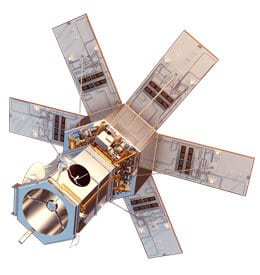
Artist rendering of the WorldView-4 satellite courtesy of Maxar (DigitalGlobe).com.

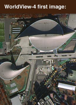
WorldView-4’s first public image, taken on November 26, features the Yoyogi National Gymnasium in Shibuya, Tokyo. The site hosted events during the 1964 Olympic Games and will again host international competition when the games return to Tokyo in 2020.
Satellite Imagery Pricing
For detailed pricing information to purchase GeoEye-1 imagery please visit LAND INFO’s Satellite Imagery Pricing page
Contact LAND INFO for a new tasking collect quote or archive image search with imagery recommendation, processing options, academic pricing and volume purchase discounts.
WorldView-4 Satellite Specifications
WorldView-4 Panchromatic Imaging Mode
Sensor Bands
450 – 800 nm
Sensor Resolution
(or GSD,Ground Sample Distance; off-nadir is geometric mean)
(or GSD,Ground Sample Distance; off-nadir is geometric mean)
0.31 m
Swath Width
13.1 km at nadir
Off-Nadir Imaging
Nominally +/- 45 degrees off-nadir
Higher angles selectively available
Higher angles selectively available
Dynamic Range
11-bits per pixel Pan and MS
Mission Life
10 to 12 years
Revisit Time
(at 40 degrees Latitude)
(at 40 degrees Latitude)
1m GSD: <1.0 day
Total Constellation > 4.5 accesses / day
Total Constellation > 4.5 accesses / day
Orbital Altitude
617 km
Nodal Crossing
10:30 am
Geolocation Accuracy (CE90)
Predicted <4 m CE90 without ground control
Capacity
680,000 km2 per day
WorldView-4 Multispectral Imaging Mode
Sensor Bands
Blue 450 – 510 nm
Green 510 – 580 nm
Red 655 – 690 nm
Near-Infared 780 – 920 nm
Green 510 – 580 nm
Red 655 – 690 nm
Near-Infared 780 – 920 nm
Sensor Resolution
(or GSD,Ground Sample Distance; off-nadir is geometric mean)
(or GSD,Ground Sample Distance; off-nadir is geometric mean)
450-520 nm (blue)
520-600 nm (green)
625-695 nm (red)
760-900 nm (near IR)
520-600 nm (green)
625-695 nm (red)
760-900 nm (near IR)
Swath Width
13.1 km at nadir
Off-Nadir Imaging
Nominally +/- 45 degrees off-nadir
Higher angles selectively available
Higher angles selectively available
Dynamic Range
11-bits per pixel Pan and MS
Mission Life
10 to 12 years
Revisit Time
(at 40 degrees Latitude)
(at 40 degrees Latitude)
1m GSD: <1.0 day
Total Constellation > 4.5 accesses / day
Total Constellation > 4.5 accesses / day
Orbital Altitude
617 km
Nodal Crossing
10:30 am
Geolocation Accuracy (CE90)
Predicted <4 m CE90 without ground control
Capacity
680,000 km2 per day


